Tan Haiqiao Yu Zhiwei
China
University of Mining and Technology, 221008 Xuzhou, China
Hydrological
Location of a City and its Role for city’s Sustainable Development[1]
Abstract
Water is one of the most important
factors for a city’s sustainable development. So a number of cities in the
world are situated beside a stream or river. With the increment of urban
population, water shortage has become a bottleneck that restricts the city’s
development. Almost all of the efforts to address such problem have got no
obvious effects. In some cities and to some extent, such efforts have formed a vicious
circle: the more the efforts being taken, the more serious, the water shortage
problem. The fundamental cause lies in underestimation of the role of
hydrological location in a city’s sustainable development.
According to Horton’s law, number of
streams of a stream order decreases as the order increases. Without human’s
interventions, these natural stream systems could certainly continue their
evolution. Since industrial revolution, however, Human activities have thoroughly
changed the stream system on the Earth, just for human being’s sake. At
present, few river systems keep untouched. Under these conditions, natural
hydrological cycle cannot run in its natural way, especially in urban areas.
What is more, population’s concentration in a city increases the water demand,
not only for a qualified daily life, but also for the industrial productions. If
we see a natural stream system in a basin as a water network, then
anthropogenic cities located on the nodes of the network are the biggest
water-consumer and destroyer of natural water cycle. It is Human being that
changed, and continues to change the river course, arbitrarily, that withdraws,
and continues to withdraw excess groundwater. Nodes’ function in a stream
network of the water cycle is often ignored.
Taking Lanzhou, Zhengzhou and Jinan
city as examples, which is located in the upper, middle, and lower reaches of
Yellow River Basin, China, respectively, we discuss the role of hydrological location
of a city in its sustainable development. Regarding the cities as nodes in a
certain stream network, we moot a model for the solution to maintain the hydrological
cycle in a city and to break away from the vicious circle in city development.
In principle, the role of hydrologic location of a city in its sustainable
development should depend on the node rank order.
1.
Any node in a stream network has
its hydrological function;
2.
Just like the stream rank order
of Horton’s law, different node has different node rank order;
3.
Node rank order is directly
proportional to the corresponding catchment’s areas in a basin, namely cities
located in a stream network with the same stream rank order could have different
hydrological location;
4.
In determining the water rights
of a city in a stream network, hydrological location should be the first weight factor;
5.
So long as the role of
hydrological location of a city is not ignored, it is possible to realize the
coordinated development of both natural stream network and anthropogenic
cities.
1.
Introduction
Water
is one of the most important factors for a city’s sustainable development. This
importance comes not only from the reliance of a city’s development on the
water, but also from the impact caused in company with the city’s development.
In comparison with the systematic studies on the river morphometry and urban hydrology[1],
less attention is paid to the study on the role of hydrological location of a city
in its sustainable development. In fact, with the increment of urban
population, water shortage has become a bottleneck that restricts the city’s
development. Almost all of the efforts to address such problem have got no obvious
effects. In some cities and to some extent, such efforts have formed a vicious
circle: the more the efforts being taken, the more serious the water shortage
problem. At present, even in south China, ‘a land of fish and rice’, man faces
also a serious water problem, especially fresh water shortage. Behind the
superficial phenomena, such as water shortage and pollution, lies a fundamental
cause: underestimation of the role of hydrological location in a city’s
sustainable development.
2.
Natural stream system and Horton’s law
 According
to the morphometric studies in the field of hydrology,initiated by
R.E. Horton and A.E. Strahler in the 1940s and 1950s,channel
segments were ordered numerically from a stream's headwaters
to a point somewhere down stream. Numerical ordering begins with the
tributaries at the stream's headwaters being assigned the value 1. A stream
segment that resulted from the joining of two 1st order segments was given an
order of 2. Two 2nd order streams formed a 3rd order stream, and so on[2].
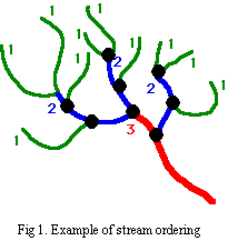
As shown in Figure 1, there are a series of natural nodes in such stream
network. All of them are located at the bifurcations (See black points in
Figure 1). If there were no anthropogenic intervention, this kind of natural
stream systems would continue its evolution on the Earth surface. And in each bifurcation
in the stream system, there would be a reasonable amount of water for evaporation,
filtration and runoff, corresponding to the upstream catchments area and the
running speed of the water at a specific bifurcation, namely at a specific node
in the stream network.
According
to the morphometric studies in the field of hydrology,initiated by
R.E. Horton and A.E. Strahler in the 1940s and 1950s,channel
segments were ordered numerically from a stream's headwaters
to a point somewhere down stream. Numerical ordering begins with the
tributaries at the stream's headwaters being assigned the value 1. A stream
segment that resulted from the joining of two 1st order segments was given an
order of 2. Two 2nd order streams formed a 3rd order stream, and so on[2].
As shown in Figure 1, there are a series of natural nodes in such stream
network. All of them are located at the bifurcations (See black points in
Figure 1). If there were no anthropogenic intervention, this kind of natural
stream systems would continue its evolution on the Earth surface. And in each bifurcation
in the stream system, there would be a reasonable amount of water for evaporation,
filtration and runoff, corresponding to the upstream catchments area and the
running speed of the water at a specific bifurcation, namely at a specific node
in the stream network.
3.
Cities’ hydrological
location
With the increment of population on the
Earth, especially with the rapid urbanization, almost every natural stream
network has been thoroughly destroyed. For most people and for a long time,
water in such stream system is just a kind of natural resource. And it is inexhaustible.
As a result, untouched stream network on the Earth, if there is any, remains
less and less. Moreover, cities located on the nodes of the stream network have
become the biggest water-consumer and destroyer of natural water cycle.
Accompanying the urbanization, human being has changed, and continues to change
the river course arbitrarily, has withdrawn, and continues to withdraw excess
groundwater. Studies in the field of hydrology illustrate that any city is not
only located in, but also belongs to a specific natural stream system. In other
words, no city could exist when isolated from natural stream system.
Hydrological location of a city mooted in this paper does not mean the
geographic location of a city but its node location in TDCN (topologically distinct
channel networks). Just as human is a part of nature, a city is also a part of
natural stream network. Wherever a city
is located, on a bifurcation or by a river, even on a mountain, it can be seen
as a node in a natural stream network. Different from those natural nodes (bifurcations)
as shown in Figure 1, all cities act as a man-made node in a natural stream
network, which should also have the functions of evaporation, filtration and
runoff. That is to say, as an actual node in a stream network, a city should
take its hydrological responsibility. Unfortunately,
in most cases the construction and development of a city are anthropocentric.
So, a city’s hydrological responsibility is often ignored, intentionally or not
intentionally. And the importance a city in hydrological cycle is often
underestimated.
4.
Hydrological location of a city and its role for sustainable
development
In general, natural hydrological cycle
needs the evaporation, filtration and runoff of precipitation not only in a
city, but more important in the stream network, where the city is located. The
amount of water for evaporation, filtration and runoff, respectively, depends
on the hydrological location, which is the function of upstream catchments area
and related natural conditions. An essential prerequisite for a city’s
sustainable development is to maintain the natural hydrological cycle. Anywhere
and anywhen, a natural stream network should keep a reasonable discharge of
river and speed of flow. In this
aspect, famous Dujiangyan irrigation project, built by Li Bing, more than 2000
years ago, in Minjiang river of Chengdu city, China, provides a fine example (Fig.2).
As a node in Minjiang river network, Dujiangyan should keep a reasonable
discharge of river and speed of flow. Li Bing’s successful project did not
ignore the hydrological responsibility in the specific node of a specific
stream network. As literature shows, about 40% of the flow is used for irrigation,
while about 60%, for natural discharge. For a city in any stream network, like
the city of Lanzhou, Zhengzhou,or Jinan in Yellow river basin, it is important
to recognize its hydrological location before planning its sustainable
development.
In principle, the
role of hydrologic location of a city in its sustainable development depends on
the stream rank order.
1.
Any node in a stream network has
its hydrological function;
2.
Just like the stream rank order
of Horton’s law, different node has different node rank order;
3.
Node rank order is directly
proportional to the corresponding catchment’s areas in a basin, namely cities
located in a stream with the same rank order could have different node rank
order;
4.
In determining the water rights
of a city in a stream network, node rank order should be the first weight
factor;
5.
So long as the role of
hydrological location of a city is not ignored, it is possible to realize the
coordinated development of both natural stream network and anthropogenic
cities.
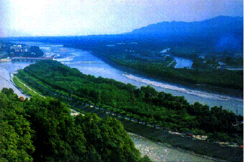
Figure
2: Famous Dujiangyan irrigation
project, in Chengdu city, China
As
well-known, humans activities, such as urbanization, result not only in the
increments of water amount needed, but also in the destroy of the whole
hydrological cycle in the natural stream network. With the process of the
urbanization, for example, more and more land surface in urban areas has been
replaced by impermeable materials, like concrete, asphalt, which cut off the
normal hydrological contact between precipitation and groundwater. On the other
hand, few surface water bodies have been left and less land surface is used for
vegetation. To address such problems
human should pay more attention to the rehabilitation of rainwater’s functions
in the hydrological cycle in the natural stream network. According to the principles mentioned above,
some practical models have been proposed for keeping hydrological cycle in
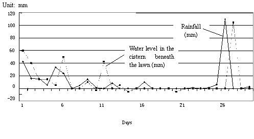
urban area. One of them is the cistern beneath a lawn (Fig.3). Data collected
from a project supported by National Natural Science Foundation of China show
that control of the rainwater storm and filtration in an urban area is not only
necessary but also feasible (Fig. 4).
With help of a man-made system, it is possible to keep the hydrological
cycle as its original status, namely to ensure the evaporation, filtration, and
water flow, just as a node at the hydrological location in a natural stream
network should do. Only when each node in a natural stream network takes its
hydrological responsibility, the natural hydrological cycle could be maintained
and the cities’ sustainable development could be realized. In determining the
water rights of a city in a stream network, hydrological location should be the
first weight factor;
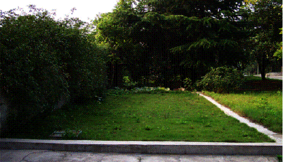
 Figure
3: A cistern beneath a lawn in the campus of CUMT
Figure
3: A cistern beneath a lawn in the campus of CUMT
Fig. 4
Relationship between the water level changes in the cistern and the
rainfalls between July 22-August 20, 2001
5.
Conclusion
Based on the discussion above,
following conclusions can be drawn:
a) Hydrological
location of a city is an important factor that affects city’s sustainable
development. So it should not be ignored or underestimated.
b) Any
city is not only located in, but also belongs to a specific natural stream
system.
c)
Hydrological location of a city
mooted in this paper means the node location in TDCN (topologically distinct channel
networks).
d) Node
rank order is directly proportional to the corresponding catchment’s areas in a
basin, namely cities located in a stream network with the same stream rank
order could have different hydrological location;
e) In
determining the water rights of a city in a stream network, hydrological
location should be the first weight factor;