RNDr. Petr Rambousek, RNDr. Pavel Lhotský GB 7
Česká geologická služba ( Czech Geological
Survey),
Klárov 3, 118 21
Praha 1, Czech Republic
The
evaluation of potential conflicts for regional planning of the mineral
resources use in the Czech Republic
Vyhodnocení potencionálních
střetů zájmů při využívání nerostných surovin pro krajské surovinové koncepce
(abstrakt)
Úkol
zadaný MPO ČR a řešený ČGS
v letech 2000 – 2003 zajistil rozpracování celostátní surovinové
politiky do podmínek nově vytvořených
krajů ČR. Vznikl dokument na podporu územního rozhodování s respektováním
ekonomického surovinového potenciálu území při zachování principů trvale
udržitelného rozvoje, včetně využívání i druhotných surovinových zdrojů.
Součástí tohoto hodnocení byla
analýza potencionálních střetů
zájmů chráněných prvků přírody a podzemních zdrojů vod. Jedním
z významných výstupů byly interaktivní mapy střetových objektů a signálů
potencionálních střetů. V syntéze s ekonomickými a kvalitativními
parametry surovinových zdrojů byla vytvořena doporučující schémata čerpání
surovinových zdrojů území. Během roku 2003 byly studie a interpretovaná data
předány krajům ČR. Během dvou let používání tohoto materiálu se ukázalo, že
realizace nekonfliktních a zdokumentovaných záměrů je v řadě případů
závislá na lokálních zájmech a aktivitách nevládních skupin.
The mineral (raw material) policy is a summary of all activities through
which the state cares for the sensitive utilisation of natural sources and the
protection of its mineral wealth. This principle is a transcript of the Article
7 of the Constitution of the Czech Republic. The state raw material policy is
the strategic document adopted by the Czech Government in 1999. It consists of
two levels – state and regional. The project of The Regional Raw Material
Policies was developed by the Czech Geological Survey and CGS-Geofond with
supervising of Ministry of Industry and
Trade and Ministry of Environment and
with help of Czech Mining Authority. The project was realised for the help of
newly established regional governments. The works started at the end of 1999
and were finished at 2003.
The raw material policy is also defined with the help and in concurrence
with land use planning whose outputs – land development documentation and land
development groundwork - can be considered as a form of declared public
interest compliant with interests protected by various regulations. The raw
material policy for land is one of the basic foundations of the elaboration of
land development documentation. The
documentation is based on the sustainable development principle.
Our study offers economic evaluation of
mineral resources and their potential accessibility at all newly
established regions of the Czech Republic. Economic evaluation is based on the
market position of commodities and on their technology availability. Potential
accessibility at this case consists in evaluating potential conflicts of
supposed mining activities with natural protection objects, underground water
sources and spa water sources.
The GIS tools were used with respect to the number of evaluated objects
and to the advantage of using digital
data sources. The data were from different sources: raw materials and mineral
resources were provided by Geofond and Czech Geological Survey; data of nature
protection objects were granted by the Agency for Nature Conservation and
Landscape Protection of the Czech Republic and by the Administration of
Protected Landscape Areas of the Czech Republic; data about protection of underground water resources were allowed
by the T. G. Masaryk Water Management
Research Institute; information about protection of spa mineral water resources were allowed by the Czech Ministry of
Health. Conflict (potential risk) analyses were realised by applying GIS
intersection tools. Small new areas affected by a conflict were found and in
the next step evaluated according to the type and areal influence of the
conflict. The results were stored at tables in numerous forms and also were
compiled to the maps of potential conflicts (Fig. 1) and simple signal maps of
conflicts.
These informations about potential conflicts areas and combination with
land use planning informations were used for constructing schemes with
recommendation of time development
exploiting of reserves of mineral resources in the region territory (Fig. 2).
These
processed informations are helpful tools for decision making processes on the
level of Regional Offices in the Czech Republic by opening informations about
the best ways to development of mining activity to public according the
Principles of Sustainable Development.
Fig.
1: Part of the potential conflicts
map in the Olomouc Region
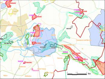
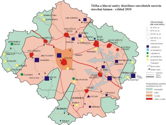
Fig.2: The scheme of
exploitation development of reserves of mineral resources about the year 2010
in Vysočina Region