Research and Mining
Activities for Nuclear Waste Management in Hungary
(Extended abstract)
István
Szűcs, Dr.a
aMECSEKÉRC Ltd.
Pécs, Hungary
1.
Introduction
According to Article 40 of the
Act No. CXVI. on Nuclear Power from 1996, the Government is liable to execute
the tasks of final disposal and interim storage of Hungarian radioactive wastes
and decommissioning of the nuclear facility. The related activities are
financed by the Central Nuclear Financial Fund, which is a separated state
financial fund. The manager of the Fund is the Hungarian Atomic Energy Agency,
which established, the Public Agency for Radioactive Waste Management (PURAM),
to accomplish the related tasks. The ongoing research programmes include two
issues: the near surface facility for low and intermediate level radioactive
wastes (L/ILW) in the Morágy Granite Formation (MGF) and the deep geological
disposal of spent fuel (SF) and high level radioactive wastes (HLW) in the Boda
Claystone Formation (BCF), both carried out and financed in form of mid- and
long-term plans and investigation programmes.
2.
Waste inventory of HLW and conditioned
L/ILW
The sources of the
national radioactive waste are diverse. The highest amount of waste is produced
by the only one Hungarian nuclear power plant, the Paks Nuclear Power Plant
(Paks NPP), with its four VVER–440 reactors, generating approximately half of
the nation’s electricity. Paks NPP was planned to produce energy for 30 years.
Due to its important role in the Hungarian energy production and the lack of
substitutive sources, a 20-year period of extension in the operation is planned
but still not decided.
Small amounts are
produced by research facilities like the training reactor of the Budapest
University of Technical and Economical Sciences, Institute of Nuclear
Technology and the research reactor in the Atomic Energy Research Institute of
the Central Physical Research Institute.
Table 1. The amount and origin
of Hungarian nuclear waste
|
WASTE TYPE |
AMOUNTS |
|
|
|
30 yrs operation
time |
50 yrs operation
time |
|
HLW [1] |
||
|
spent fuel (Paks NPP) |
11 266 pieces |
18 706 pieces |
|
spent fuel (other sources) |
3 225 pieces |
3 225 pieces |
|
operational wastes |
173 m3 |
263 m3 |
|
decommissioning wastes |
247 m3 |
247 m3 |
|
Püspökszilágy RWTDF a |
100 m3 |
100 m3 |
|
conditioned L/ILW [2] |
||
|
solid waste |
2 547 m3 |
ND |
|
ion exchange
synthetic resin |
639 m3 |
ND |
|
evaporation
residue |
16 067 m3 |
ND |
|
other
liquid wastes |
1 649 m3 |
ND |
a Radioactive Waste
Treatment and Disposal Facility
3.
The research projects
(a)
The BCF
programme for the final disposal of spent fuel and high-level radioactive waste
started as a preliminary characterization programme between 1989-1992, which
was followed by the Alfa Project (1993-1995) and the Short Term Project
(1996-1999). These latter two projects were carried out underground in the so-called
Alfa shaft, which reached the BCF through an investigation shaft driven from
the sandstone block of the former uranium mine near the city of Pécs. The
technical co-ordinator of the underground research was MECSEKÉRC Ltd., the
official controller was PURAM. The results were summarized in a 10-volume
report published by MECSEKÉRC Ltd. in 1998. In 1999 the shafts and tunnels of
the uranium mine were filled back, therefore the access to the Alfa shaft was
blocked irrecoverably. The two phase (the site selection and the site
characterization phase) Middle Term Project, started in 2003, is planned to
have been completed by 2008.
(b)
The MGF
programme for the final disposal of low- and intermediate-level radioactive
waste started with site selection in 1993 and ended in 1996. The results of
this period were published in the Annual Report of the Geological Institute of
Hungary (MÁFI), 1996/II and were followed by the site characterization running
till 1999. The ground-based exploration was carried out in 2002-2003 under the
responsibility of Bátatom Ltd., a consortium of four institutes and companies:
Geological Institute of Hungary (MÁFI), ETV-Erőterv, Golder Associates Hungary
and MECSEKÉRC Ltd.
4.
The main goals of the MGF research
programme
The research activities for
the subsurface
investigation phase started in
2004 have different goals:
(a)
To find and
locate a suitable rock body for the repository. This means that the
investigations focus on the expected repository level after the establishment
the inclined tunnels. To reach the goal all necessary measures shall be taken,
including additional studies from the ground surface.
(b)
To
characterize the selected rock to provide data for the design and construction
of the repository and the safety analysis. It is necessary to have a
preliminary layout to position the characterization boreholes in a reasonable
way to avoid disadvantageous hydraulic connections within the repository
volume.
(c)
To better
understanding the geology, tectonics, geotechnics and hydrogeology of the site.
The access tunnels will provide a good opportunity to study these topics in the
actual environment. Their construction can be regarded as a training phase to
learn how the rock mass actually behaves and influences the surroundings.
5.
Investigation of MGF at Bátaapáti
The complementary survey at Bátaapáti was carried out in the scope of
the geological exploration aimed at the final disposal of low- and
intermediate-level radioactive waste. The measurements were related to the
drilling activity, in 2002-2003, and were made in the centralpart and its
closely connected area.
The conditions of the area from a geophysical aspect are unfavourable.
The physical parameters of the loess, which is a 40-60 m thick cover on the
granite body, makes it hard to apply both electromagnetic and seismic methods
to investigate the granite mass and the Bátaapáti site.
The results of geophysics are unusable without geological or
hydrogeological explanation. Fortunately, examinations conducted by other
methods in the area produced a large amount of data, thus facilitating the
geophysical interpretation.
The geophysical methods used did not image the geological structures
directly but the physical variations of the rock were explored. Parameters
measured by geophysical methods usually
represent average values of a space domain determined by the resolution.
5.1 Seismic tomography
Seismic tomography is an image reconstruction technique. If measured
data are line integrals of the observed physical quantity, the distribution of
the physical quantities of the inner structure can be determined from
measurements carried out along the boundary of the given domain. Such a kind of
connection between wave propagation types and the reciprocal of the velocity,
and between the logarithm of the amplitudes and the absorption, is known from
seismic studies. The distribution of velocity and absorption can be determined
by seismic tomography when the propagation times and amplitudes between shot
points and geophones are measured along ray paths crossing each other. To get a
reliable profile of adequate resolution the observed area must be covered
uniformly by a multitude of rays in conformity with direction and number.
At the Üveghuta Site seismic tomographic measurements were carried out
between adjoining pairs of boreholes in the technically executable depth
ranges. To calculate the velocity propagation parameters in the granite only
the data from the boreholes were used. If the sources or receivers were to be
placed into the low-velocity loess layers the tomographic data system would be
charged with considerable errors. This is because the thickness of the loess
can be determined at only one cell precision and this time delay is comparable
with the total runtime in the granite. The starting model and the boundary
conditions for the SIRT (Simultaneous Reconstruction Technique) computer
algorithms were provided by PSQ and PQ seismic borehole data (where P and S are
seismic body waves, Q is the quality factor). The computation is based on the
modification of the wave propagation parameters along raypaths, which cross
each other in the space domain between boreholes until the misfit between
computed and measured parameters is minimal.
The resolution of tomography between boreholes is direction-dependent,
especially in the case of large borehole distances because of the partial
absence of near vertical rays; consequently steep elements are not imaged.
Another inherent characteristic of imaging is that the accurate velocity of a
small-sized, low-velocity structure is not mapped adequately by the tomography:
it is “smeared” because the rays do not cross the given structure (Fermat’s
principle).
The results of the tomographic measurements at the site show some spots
or stripe-like low- or high-velocity granite bodies. The structures are
considered to be 2D because of the lack of 3D data. Most of the low velocity
bodies can be observed at rather shallow depths. In boreholes
Üh-23-Üh-2-Üh-22-Üh-3, where the geometry was the most favourable, the velocity
and absorption tomographic sections resolved even steep dipping elements [3]
[4]. It can be inferred from resolution parameters that tomographic spots and
forms of zones do not necessarily display the peculiarities of the parameters
recognized in drill-core or well logs. With this method changes comparable to
the wavelength can be observed. These changes are caused by the granite
material, the fissures in the granite, the fissure infillings, the direction of
fissures etc.
Experiences at the Üveghuta Site show that seismic velocity and
absorption are less affected by the rock stresses and the rock material, but
they depend definitely on the rock-mechanical conditions.
The results of velocity and absorption tomography should be interpreted
together: their data along the boreholes are in good correlation with smoothed,
averaged well-log data principally with electric resistance, acoustic and
seismic velocity sections.
5.2 Imaging the granite inside
Geophysical information with the best resolution is provided by the
well-logging applications because they made measurements in the immediate
vicinity of the observed material. In spite of the good resolution of the
methods, the measured parameters do not generally correlate, even in closely
spaced boreholes. For the macro-level spatial description of the extent of the
granite body, the number of boreholes and the interpretation of well-logging
data are insufficient altogether.
There is a special character of the granite body beyond what can be
observed in the boreholes and that is the variability in the scale between
boreholes. This can be imaged with the best resolution by seismic cross-hole
methods.
Lacking other possibilities the tomographic results were evaluated as
phenomena with clear changes in the plane of the boreholes, while the changes
of the actual granite show 3D features. This is verified by seismic tomographic
sections which were measured in the nearby planes of Üh-3-Üh-23, and
Üh-3-Üh-22-Üh-2-Üh-23. Comparing the suitability of methods for extension of
the attributes to the area inside and between the boreholes, the
magnetotelluric method, 3D seismic first break tomography and S-wave reflection
profiling are suitable from point of view of the order of resolution at the
investigated area. The integrated interpretation of the borehole tomography
outlined the inner structure of the granite. The granite bodies are defined by
seismic tomography (Fig. 1).
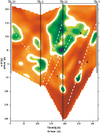
Fig. 1. Absorption tomographic section between boreholes
5.3 Conclusions
The methods described contributed fundamentally to the investigation of
the surface and to the knowledge of the spatial characteristics of the granite.
The granite in the boreholes, and in its extended surroundings, can be well
characterized by seismic tomography. The weakened zones between the bodies
could have importance from the point of view of water conduction and mining
activity based on “design as you go” practice.
References
[1] Takáts, F., Baksay, A., Back-end stratégia elemeinek tisztázása, a várható hulladék
mennyiségeinek számítása (Report on the elements of the back-end strategy and
the potential inventory of spent fuel and high level radioactive waste in
Hungary). – Manuscript, TS Enercon, Budapest, Hungary, (2004)
[2] Takács, T. et al., Összegző biztonsági jelentés, (BA-04-18), (Safety
Case, Summary), Hungary (2004)
[3] Prónay, Zs., Tőrös, E., Jelentés a szeizmikus sebességtomográfiáról (Report on the
seismic velocity tomography). Manuscript, Eötvös Lóránd Geophysical Institute
of Hungary, Budapest, Hungary, (2003)
[4] Szűcs, I., Menyhei, L., Gacsályi, M., Jelentés az üveghuta körzetében 2002-2003-ban
végzett abszorpciós tomográfiai mérések feldolgozásáról (Report on the processing of
the seismic absorption tomography conducted in the vicinity of Üveghuta in
2002-2003). – Manuscript, Geopard Kft., Pécs, Hungary, (2003)